Experts now estimate there’s a 7–15% chance that the Cascadia Subduction Zone could trigger a magnitude-8.0 or stronger earthquake within 50 years, according to the latest U.S. National Seismic Hazard Model. A full rupture could bring minutes of violent shaking and unleash a tsunami nearly 100 feet high.
Over nine million people in the Pacific Northwest are in harm’s way. The danger is real—yet most communities still aren’t fully prepared.
Southern Oregon Is Overdue

A major Oregon State University study found a 40% chance that a powerful earthquake could hit the southern Oregon coast near Coos Bay within the next 50 years. This part of the Cascadia fault breaks more often than the northern segment, putting towns like Brookings and Newport at heightened risk.
Insurers are taking note. In California, rates are already shifting based on new models, though similar adjustments in Oregon remain inconsistent.
A Warning from the Past
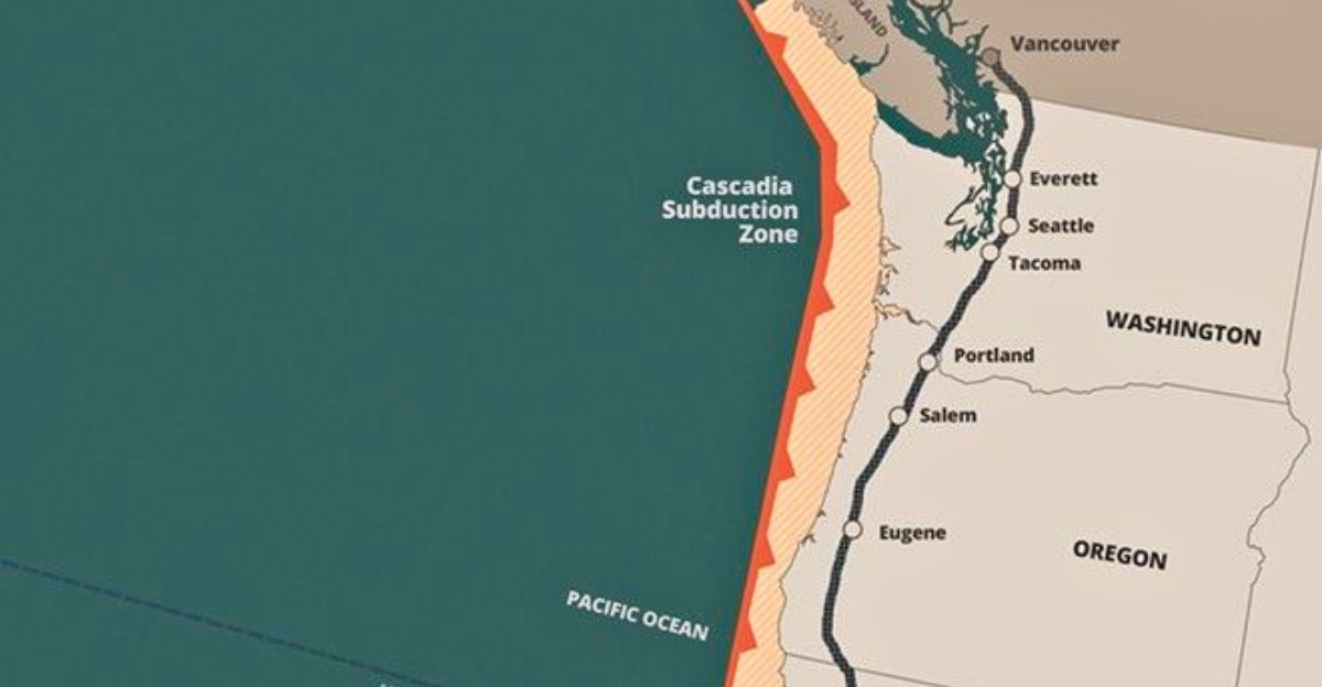
On January 26, 1700, a massive quake—estimated between magnitude 8.7 and 9.2—ruptured the full length of the Cascadia Subduction Zone around 9:00 p.m. Pacific time. It drowned coastal forests and launched a tsunami that struck Japan 10 hours later.
Scientists confirmed the event through ghost forests and Japanese records of an unexplained “orphan tsunami.” More than 300 years later, pressure is still building. Experts agree: it’s not if, but when.
A Fault That’s Flexing

Roughly every 14 to 15 months, scientists detect “slow-slip” events along the Cascadia Subduction Zone, quiet, deep movements that unfold over several weeks. These episodes are part of the region’s natural tectonic rhythm.
Although they slightly shift stress along the fault, there’s no solid evidence linking them to an immediate quake risk. Researchers are still studying their role, but so far, no direct connection to a coming rupture has been confirmed.
The Forecast That Changed Everything

In January 2024, the U.S. Geological Survey updated its National Seismic Hazard Model to include a full-length Cascadia megathrust scenario, featuring four to six minutes of intense shaking and a 7–15% chance of striking within 50 years.
This forecast is reshaping building codes, insurance policies, and emergency planning across the West Coast. As the science becomes clearer, the pressure is mounting for lawmakers to invest in essential infrastructure upgrades before time runs out.
The Ground Will Drop

Recent research from Virginia Tech and PNAS warns that a major Cascadia quake could cause land in 24 coastal estuaries to sink as much as 6.5 feet. This “permanent subsidence” would instantly enlarge flood zones by 116 square miles, before climate change even enters the equation. Essential infrastructure like ports, airports, and wastewater plants could fall below the high-tide line. That makes sea-level rise a double threat. Local governments are now scrambling to update zoning laws.
Racing the Waves

In 2022, the Shoalwater Bay Tribe built a 50-foot tsunami evacuation tower on Washington’s Tokeland Peninsula—the first free-standing structure of its kind in the U.S. It holds over 400 people, enough for the entire community.
Before the tower, evacuation could take up to 90 minutes—far longer than the tsunami’s expected 15–35 minute arrival. Most coastal towns still lack these towers, despite experts calling for 50-plus. The Shoalwater model shows what’s possible when urgency meets action.
Building Delays Could Cost Lives

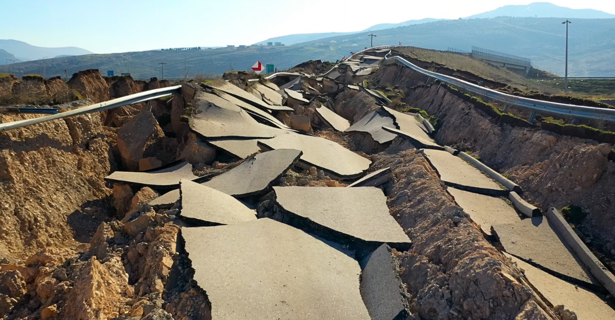
British Columbia postponed major seismic code changes until March after builders warned of sharp cost increases. Under the new rules, Victoria buildings must handle up to 45% more ground force, requiring stronger materials and designs. Many developers are now rushing to file permits under the old codes. Critics worry this rush will cement structural weaknesses that won’t be fixed until it’s too late. Will short-term savings put long-term safety at risk?
The Power Grid’s Breaking Point

In 2019, a cold snap nearly caused a blackout in the Pacific Northwest when hydroelectric, wind, and coal systems all faltered at once. A later report by the Western Electricity Coordinating Council warned that a Cascadia quake could cut off transmission lines and leave cities in the dark for weeks. Utilities are investing in battery storage and long-distance connections, but experts say retrofits are still lagging. If the quake hits soon, the region may not stay powered.
Flood Risk Is Already Rising

Recent models show that even without future sea-level rise, a full-length Cascadia rupture today would push over 14,000 more people and 22,000 buildings into the 100-year flood zone.
By 2100, those numbers could more than triple as sea levels rise up to 3 feet. Saltwater could ruin farmland, wetlands may vanish, and key roads could flood permanently, delaying recovery for years. Local planners face growing urgency to act before land and water collide.
Which Bridges Will Hold?

Simulations from the University of Washington show most inland I-5 highway bridges in western Washington will likely withstand a magnitude-9 Cascadia quake, especially those built or updated after 1976. However, many older coastal bridges are expected to fail or suffer severe damage.
This leaves officials with a tough choice: focus limited funds on inland evacuation routes or shore up vulnerable coastal infrastructure. Truckers warn detours could stretch hundreds of miles.
Fuel Could Run Dry

The Oregon Department of Energy warns that a full Cascadia quake could cause up to 250 breaks and 82 leaks in the Olympic Pipeline, cutting off 90% of the region’s liquid fuel supply. Portland’s Critical Energy Infrastructure Hub sits on soil prone to liquefaction, risking tank failures, spills, and fires.
All jet fuel for Portland International Airport passes through this hub, raising post-quake supply challenges. Officials advise residents to prepare for two weeks without outside help.
Every Second Counts

As of July, the ShakeAlert system uses over 1,500 monitoring stations across the West Coast, aiming for 1,675 by year’s end. Its GFAST algorithm quickly estimates earthquake magnitude and sends automatic warnings to millions of smartphones and critical facilities within seconds.
Though the technology is ready, public outreach varies. Some counties lag due to funding. Experts emphasize that every second counts, but alerts only save lives if people are trained and warnings reach them reliably.
Outdated Designs Still Stand

British Columbia’s 2024 seismic bulletin allows many rural projects with permits filed before March 2025 to use older, less-effective bracing and wood-frame standards until at least 2027. Engineers warn these buildings face high collapse risks in a major quake.
Calls for retrofit incentives are strong, but political debate and cost concerns have slowed progress. This leaves many communities with a patchwork of both safe and vulnerable homes.
When the Ground Moves

FEMA’s latest Cascadia Rising scenario estimates a full rupture could cause up to 25,000 deaths and over $130 billion in damages. Emergency planners consider this a real possibility in 2025.
Officials warn preparedness is racing a silent geological clock, the fault could rupture without warning. Experts agree every step matters, from family kits to infrastructure upgrades. The Pacific Northwest’s legacy will depend on what’s done before the ground starts shaking.